WELCOME TO Stamford, CT

squiggle

Stamford is a city in Fairfield County, Connecticut, 34 miles outside of New York City. It is the largest city in the Western Connecticut Planning Region, and Connecticut’s second-most populous city, behind Bridgeport. With a population of 135,470, Stamford passed Hartford and New Haven in population as of the 2020 census. It is in the Bridgeport-Stamford-Norwalk-Danbury metropolitan statistical area, which is part of the New York City metropolitan area (specifically, the New York–Newark, NY–NJ–CT–PA Combined Statistical Area).

As of 2023, Stamford is home to eight Fortune 500 companies and numerous divisions of large corporations. This gives it the largest financial district in the New York metropolitan region outside New York City and one of the nation’s largest concentrations of corporations. Dominant sectors of Stamford’s economy include financial management and real estate, tourisminformation technologyhealthcaretelecommunicationstransportation, and retail. Its metropolitan division is home to colleges and universities including UConn Stamford and Norwalk Community College.

Stamford was known as Rippowam by the Siwanoy Native American inhabitants of the region, and the very first European settlers in the area also called it that. The present name is after the town of Stamford, Lincolnshire, England. The deed to Stamford was signed on July 1, 1640, between Captain Turner of the New Haven Colony and Chief Ponus. By the 18th century, one of the town’s primary industries was merchandising by water, which was possible due to Stamford’s proximity to New York.

squiggle

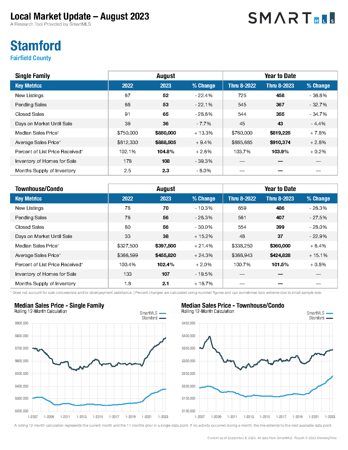
Local Market Update for August, 2023

Stamford Market Update - August, 2023

Geography

Total area: 52.09 square miles; 37.62 square miles is land and 14.41 square miles is water. Stamford is the state’s largest city by area. Stamford is located between Manhattan and New Haven at approximately 38 miles from each; 79 miles from the state capital of Hartford. Stamford is the southwestern point of Connecticut, on Long Island Sound; and part of the “Gold Coast”. Stamford comprises approximately 45 distinct neighborhoods and villages, and 2 historic districts, including Cove, East Side, Downtown, North Stamford, Glenbrook, West Side, Turn of River, Waterside, Springdale, Belltown, Ridgeway, Newfield, South End, Westover, Shippan, Roxbury, and Palmers Hill.

North of the Merritt Parkway is considered the North Stamford section of the city, encompassing its largest land mass though it is the least densely populated. North Stamford functionally and legally acts as one municipality with the city of Stamford. Stamford borders Pound Ridge, New York to the north, the Long Island Sound to the south, Greenwich to the west, Darien to the east, and New Canaan to the northeast.

The city has islands in Long Island Sound: Cove Island, Grass Island, Greenway Island, Jack Island, and Cuties Island (also known as Vincent Island). Cove Island is a prominent beach and recreation area. It lies approximately 9 miles (14 kilometers) from Norwalk.

Neighborhoods

Cove

East Side

Downtown, North Stamford

Glenbrook

West Side

Turn of River

Waterside

Springdale

Belltown

Ridgeway

Newfield

South End

Westover

Shippan

Roxbury

Palmers Hill

Demographics

2020 Census: Population of 135,470. Stamford had surpassed New Haven’s population, making it the state’s second-most populous city, behind Bridgeport.

Racial makeup as of 2020): 49.3% non-Hispanic white; 14.1% Black or African American; 0.3% American Indian or Alaska Native; 8.6% Asian American; 3.2% from two or more races; 27.2% Hispanic or Latino. Guatemalans form the largest group (6.75% of the city’s population), followed by Puerto Ricans (3.77%), Colombians (2.87%), Ecuadorians (2.42%), and Mexicans (2.38%). In 2018, 5.9% of the city was West Indian.

Median age: 37.2.

Housing Units: 54,513.

Households: 50,847.

Average household size was 2.53.

31,347 families living in the city.

Owner-occupied housing rate: 46.6%.

Renter-occupied housing rate: 53.4%.

Median household income (in 2021): $99,792.

Per capita income: $58,297, the highest of any city in Connecticut.

Average household income: $143,222.

About 9.3% of the population was at or below the poverty line.

The largest religious groups in the city are: Christians, Judaism, Islam, Eastern religions including Hinduism and Buddhism.

Largest Christian denomination: Roman Catholic Church.

Economy

Recreational Facilities

  • Mill River Park.
  • Cummings Park.
  • Cove Island Park.
  • Jackie Robinson Park.
  • Terry Connors Ice Rink.
  • Scalzi Park.
  • Sterling Farms Golf Course.
  • The E. Gaynor Brennan Golf Course, known locally as Hubbard Heights.
  • Dorothy Heroy Park.
  • Mianus River Park.
  • Italian Center.
  • Stamford YMCA.
  • Stamford Yacht Club.

Education

Elementary Schools (13):

Davenport Ridge Elementary School.

Hart Magnet Elementary School.

Julia A. Stark Elementary School.

K.T. Murphy Elementary School.

Newfield Elementary School.

Northeast Elementary School.

Rogers International School.

Roxbury Elementary School.

Springdale Elementary School.

Stillmeadow Elementary School.

Strawberry Hill School (extension of Rogers International).

Toquam Magnet Elementary School.

Westover Magnet Elementary School.

Middle Schools (5):

  • Cloonan Middle School
  • Dolan Middle School
  • Rippowam Middle School
  • Scofield Magnet Middle School
  • Turn of River Middle School

High schools (3):

Westhill High School.

Stamford High School.

Academy of Information Technology and Engineering.

Private schools (4): Villa Maria School; Bi-Cultural Jewish Day School; King Low Heywood Thomas; The Long Ridge School.

Universities: Branches of the University of Connecticut, University of Bridgeport and Sacred Heart University.

Stamford has one of the nation’s most highly educated populations: nine out of ten are high school graduates, and those possessing a bachelor’s degree or higher are estimated at 43.6% of the population.

Stamford is tied with Iowa City, Iowa, for the U.S. metropolitan area with the highest percentage of the adult population holding a bachelor’s degree or higher; 44% of adults hold a degree.

Transportation

Train:

New Haven Line of the Metro-North Railroad, the commuter rail system for northern metropolitan New York City.

Acela, the high speed train service between Boston and Washington.

Airports:

Stamford is within reasonable distance of 11 airports: four general aviation, two regional, five international.

Buses:

City bus transportation is provided by CT Transit.

Highways:

Interstate 95, runs through downtown Stamford and North and South, with four exits 6 through 9.

Merritt Parkway runs North and South.

Stamford is also served by 4 other state highways:

Route 1, also known as Main Street.

Route 137 (Washington Boulevard and High Ridge Road) is the main north–south road of the city and runs from the Stamford Transportation Center and serves the Turn of River, North Stamford, and High Ridge sections of the city.

Route 104 (Long Ridge Road) branches off from Route 137 to serve the Long Ridge section.

Route 106 (Courtland Avenue) serves the Glenbrook neighborhood and continues towards the town of Darien.

Notable People