WELCOME TO Darien, CT

squiggle

Darien is a coastal town in Fairfield County, Connecticut, United States. With a population of 21,499 and a land area of just under 13 square miles, it is the smallest town on Connecticut’s Gold Coast. The town is part of the Western Connecticut Planning Region. It has the youngest population of any non-college town in Connecticut, a high rate of marriage, and high average number of children per household.

Situated on Long Island Sound between the cities of Stamford and Norwalk, the town has relatively few office buildings. Many residents commute to New York City, with two Metro-North railroad stations, Noroton Heights and Darien, which link Darien to Grand Central Terminal. For recreation, the town boasts eleven parks, two public beaches, the private Tokeneke beach club, three country clubs including the first organized golf club in Connecticut, a riding and racquet club, the public Darien Boat Club, and Noroton Yacht Club.

According to early records, the first clearings of land were made by men from the New Haven and Wethersfield colonies and from Norwalk in about 1641. It was not until 1739, however, that the Middlesex Society of the Town of Stamford built the first community church, now the First Congregational Church of Darien, which stands on the original site at the corner of Brookside Road and the Boston Post Road.

squiggle

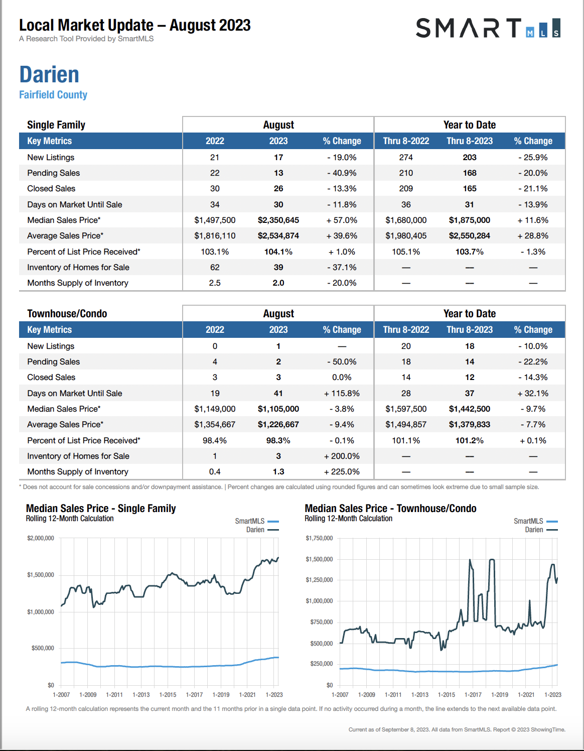
Local Market Update for August 2023

Darien-market-report-Aug2023

Geography

Total area: 14.8 square miles, 12.9 square miles is land and 2.0 square miles or 13.41%, is water.

The town has 16.5 miles of coastline and five harbors.

It also has two Metro-North railroad stations for commuter trains into New York City, with a 38 to 39 miles commute of 46–50 minutes from Noroton Heights and 49–53 minutes from Darien.

In addition, the Glenbrook railroad station and the Talmadge Hill railroad station, both on the New Canaan Branch, are within walking distance of homes near the Holmes elementary school and at the far northwestern corner of town.

The Rowayton railroad station on the New Haven Line is also within walking distance of homes near Raymond Street in the southeastern part of town. Most trains run non-stop after Stamford into New York City’s 125th Street, then Grand Central Terminal.

Along with the New Haven Line of Metro-North Railroad and Interstate 95, US Route 1, known locally as the Boston Post Road, or, more commonly, the Post Road, runs east–west through the southern side of town. Except for the Noroton Heights business district, commercial zoning is extremely limited outside of the town-wide strip along the Post Road.

Darien is bordered on the west by Stamford, on the north by New Canaan, and on the east by Norwalk. On the south it faces Long Island Sound and the North Shore of Long Island. It is part of the “panhandle” of Connecticut jutting into New York state. The town has 16.5 miles of coastline and five harbors.

Neighborhoods

In addition to some small neighborhoods, the larger divisions of the town are:

Downtown Darien (area surrounding Boston Post Road from I-95 to Brookside Road).

Noroton (roughly in the southwest corner of town on Boston Post Road).

Ox Ridge (northern end of Mansfield Avenue).

Noroton Heights (roughly north of Interstate 95 to Middlesex Middle School with an eastern boundary of Noroton Avenue).

Springdale (adjacent to Stamford’s Springdale neighborhood).

Long Neck Point (southernmost part of town up to historic Ring’s End Landing).

Tokeneke (mostly private community in the southeastern end of town).

Demographics

Population: 19,607 people, 6,592 households, and 5,385 families.

Housing Units: 6,792.

Racial makeup: 95.97% White, 0.45% African American, 0.04% Native American, 2.42% Asian, 0.03% Pacific Islander, 0.30% from other races, and 0.80% from two or more races. Hispanic or Latino of any race were 2.19% of the population.

6,592 households, of which 46.4% had children under the age of 18 living with them, 74.5% were married couples living together, 5.6% had a woman whose husband did not live with her, and 18.3% were non-families.

Of all households 15.6% were made up of individuals, and 8.3% had someone living alone who was 65 years of age or older. The average household size was 2.95 and the average family size was 3.31.

In the town, the population was spread out, with 32.5% under the age of 18, 3.0% from 18 to 24, 28.2% from 25 to 44, 24.0% from 45 to 64, and 12.4% who were 65 years of age or older. The median age was 38 years. For every 100 females, there were 96.2 males. For every 100 females age 18 and over, there were 89.7 males.

2019 Median Income: $232,523; per capita income was $116,564.

Darien has been ranked the #1 safest “city” in Connecticut for 2018 by Safewise, and the 54th safest city in the United States.

Economy

JetBlue Airways once had its finance and scheduling operations at 19 Old Kings Highway South in Darien. In mid-2012 JetBlue combined the Darien and Forest Hills, Queens, New York City headquarters into its headquarters in Long Island City, Queens.

Recreational Facilities

Darien YMCA.

The Depot.

Darien Ice House – Darien’s sole ice rink.

Education

Darien is served by the Darien Public Schools, and Darien High School was ranked No. 1 in the “U.S. News Best High Schools in Connecticut” in 2019. The school also ranked in the top 150 in the national rankings, and in the top 50 in STEM high schools in the United States.

Elementary Schools (5):

Hindley School.

Holmes School.

Ox Ridge School.

Royle School.

Tokeneke School.

Middle Schools (1):

Middlesex Middle School.

High Schools (1):

Darien High School.

In June 2012, 24/7 Wall St. ranked Darien as the 10th wealthiest school district in the United States.

Transportation

The town is served by two train stations, one in Noroton Heights and the other in downtown Darien.

The Connecticut Turnpike (Interstate 95) runs through town, as does the Post Road, U.S. Route 1. Just to the north of town, the Merritt Parkway (Route 15) runs roughly parallel to the northern border between Darien and New Canaan.

The Talmadge Hill railroad station is just north of the border as well. Along with the Post Road, major east–west thoroughfares in town are West Avenue and Middlesex Road. Major north–south roads are Hoyt Street, Hollow Tree Ridge Road, Nearwater Lane, Noroton Avenue, Middlesex Road, Mansfield Avenue and Brookside Road.

Interstate 95 has rest stops in Darien both for the southbound and northbound lanes. The state Department of Transportation has added “speed change” lanes between entrances and exits up to Exit 10 (and points westward).

About 150,000 vehicles pass Exit 12 each day, according to the state Department of Transportation.

Notable People